

There is a lot to see in Pocahontas County, a rural county in West Virginia. From geologic rock formations to scenic overlooks to hiking to beautiful old barns to wildlife… you won’t have enough time to do it all!


Take a drive along the Highland Scenic Highway, which runs 43 miles through the Monongahela National Forest, meandering along the mountain ridges, reaching an elevation of more than 4500 feet.


You’re going to miss out if you don’t stop at all four overlooks. Pack a picnic lunch, because at each of the overlooks are covered picnic tables: you can eat your lunch while enjoying an incredible view over the mountains. (There are also rustic bathrooms and garbage cans.) While you’re there, be sure to make stops to go on some short hikes along the scenic highway: Honeycomb Rocks, a scant .3 mile out and back, Cranberry Glades Boardwalk and the Falls of Hills Creek.
Getting there: The road runs north to south-ish: you can pick up the northern-most terminous at U.S. 219 and WV 55 north of Edray, near Marlinton or the southern terminous of WV 150 at WV 39 and WV 55 northwest of Mill Point. For the southwestern section of the Highland Scenic Highway, you’ll follow WV 39/WV 55 north.
Website: Highland Scenic Highway and Highland Scenic Highway Brochure


Just off the Highland Scenic Highway is the Falls of Hills Creek, one of West Virginia’s hidden gems! The Falls of Hills Creek is a series of three falls that cascade 20 feet, 45 feet, and the third 63 feet, , making it the second tallest falls in West Virginia. The waterfalls are viewable via a short 1.3 mile, out and back hike that drops down into the valley a total of 272 feet via 380 stairs.
As you visit the falls, each one gets better than the other — and the Lower Falls plummets spectacularly over a cliff. There is a paved path to a platform from which you can view the upper falls.
Getting there: From the North and East via Interstate 79, use Exit 57 onto US Route 19 South to State Route 55. Take WV 55 through Richwood to the Falls of Hills Creek. Approximately 65 miles from Exit 57. From South and East via Interstate 64 use Exit 169 onto US 219 North to State Route 39/55. West on WV 39/55 to Falls of Hills Creek. Approximately 42 miles from Exit 169 in Lewisburg.
Website: Falls of Hills Creek


A perfect base for your stay is Watoga State Park, which offers cabins or camping. We chose the cabins, twice. We found several trails worth hiking — leading to payoff scenic views or simply offering a delightful tromp in the woods. The park — West Virginia’s largest — covers more than 10 thousand acres, and began as a state forest designated as a wildlife and timber preserve.
There’s a small lake for fishing, paddle-boarding, or kayaking. During the warmer months, there’re tennis courts and a swimming pool (if you stay in the cabins in the park, you can swim free.) It’s within an easy drive of everything mentioned in this article.
Getting there: 4800 Watoga Park Rd, Marlinton, WV
Website: Watoga State Park
Adjacent Watoga State Park is the Greenbrier River Rail Trail, a linear state park protecting the almost 78-mile rail trail — the longest rail trail in West Virginia — between North Caldwell and Cass in eastern West Virginia. It runs through Pocahontas and Greenbrier counties, mostly within sight of the Greenbrier River.
Getting there: Map of Access Points
Website: Greenbrier River Rail Trail


Nearby is the Pearl S Buck birthplace — closed both times we visited Watoga State Park — and Droop Mountain State Park, the site of a Civil War skirmish. The view from the Droop Mountain Overlook, accessed through the park, is lovely!
Getting there: the Pearl S Buck birthplace is located at 8129 Seneca Trail (Route 219), Hillsboro, WV; Droop Mountain State Park is located at 683 Droop Park Road, Hillsboro, WV
Websites: the Pearl S Buck Birthplace; Droop Mountain Battlefield State Park


For a fun day filled with gorgeous views over the mountains, then ride the Cass Scenic Railroad, an 11-mile long heritage railway owned by the West Virginia State Rail Authority and operated by the Durbin and Greenbrier Valley Railroad. Originally, the Cass Railroad hauled lumber off the mountain to the mill at Cass. Today, the scenic railroad brings visitors to the top of Bald Knob, the third highest mountain peak in West Virginia. When we were there, several deer were “trained” to come up to the train because the conductors always had an apple to share with them!
Getting there: 12363 Cass Rd, Cass, WV
Website: Cass Scenic Railroad State Park


Green Bank Observatory, the nation’s first national astronomy observatory, is an interesting stop to see and appreciate the eight giant telescopes aimed toward distant parts of our universe. The observatory is also why most of Pocahantas County is in a national radio quiet zone, i.e., no cell phone service or signals. GPS can be dicey. Also good to know is that the scientific work performed at Green Bank Observatory necessarily limits the use of electronic devices onsite, including digital cameras and smartphones.
Getting there: 155 Observatory Road, Green Bank WV
Website: Green Bank Observatory
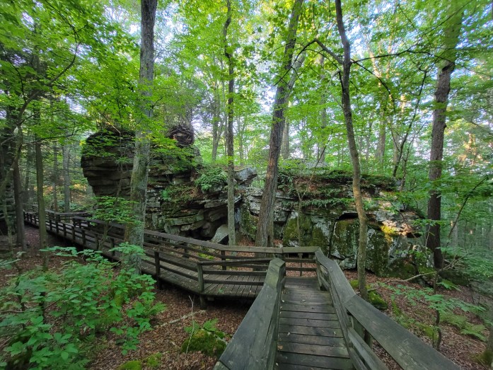


Bear Town State Park is an iconic West Virginia state park that I could visit over and over again. Huge fragmented boulders fill the forest, creating the sense that you’re in a small town — the local community imagined that bears inhabited the crevices between the huge boulders, hence the name of the area. The boardwalk carries you over, into and through the crevices, allowing you to fully explore the local ecosystem and this incredible natural wonder. This is a great place to unleash your kids and let them burn off some energy.
The boardwalk makes a big loop through the state park — it’s just a half mile long — a small portion of which is wheelchair accessible. Some have marveled that the boardwalk construction is nearly as impressive as the rock formations.
Getting there: Beartown Rd, Renick, WV
Website: Beartown State Park
One of the special things I appreciated about this rural West Virginia county is that even while driving between the daytrip destinations, there was much to see and appreciate — from scenic countryside to rural barns and interesting rock formations that can be seen from the highways and byways. This is truly a slice of almost heaven!


